(Delmarvanow.com) -- For all of its many tons of concrete and steel, the $150 million launch pad at Wallops Flight Facility would be no match for Mother Nature.
The imposing structure is sturdy enough to send rockets into space. But it was built on a barrier island, which, by its very nature, is given to shift its features over time, scientists say.
Sometimes, the changes take place over scores of years, such as the retreat of a coastline in the face of rising seas. Sometimes, they happen all at once, like during a hurricane.
Researchers from three Mid-Atlantic universities are teaming up to develop a first-of-its-kind geological road map of Wallops Island and the surrounding area. The goal, they say, is to show how sands have ebbed and flowed in the past so they can better predict how the vulnerable strip of land will change in the future.

"How do you manage a resource when you don't have a map to know where the resource is?" asked Art Trembanis.
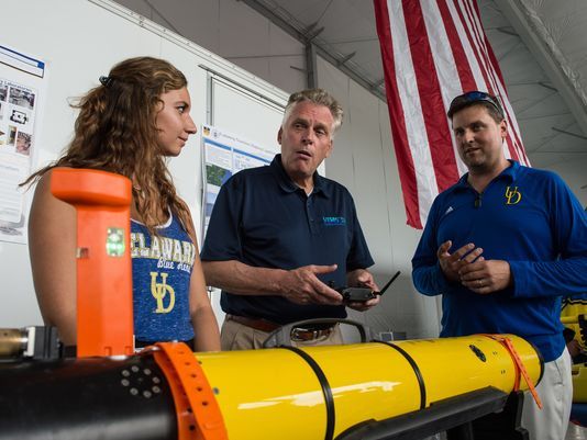
The University of Delaware oceanography professor is partnering with colleagues from the Virginia Institute of Marine Science and Randolph-Macon College on a preliminary mapping effort, taking place over this weekend.
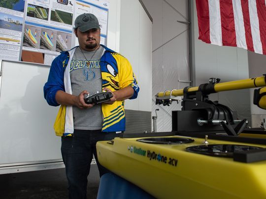
Virginia Gov. Terry McAuliffe visited their base of operations Friday afternoon at a new runway on the northern tip of the island designed specifically for unmanned aerial vehicles, or drones. The researchers plan to use robotic technology by land, sea and air to gather information.
For McAuliffe, the endeavor offered an opportunity to tout one of his favorite subjects: the state's push to become an early leader in the drone industry.

"We've put a lot of time and effort into this," he said, addressing an audience that included top NASA Wallops officials, local dignitaries and university professors and students.
Pointing to the $5.8 million runway, which he dedicated in May, McAuliffe said: "This is going to be transformational for the whole region down here in Wallops Island. It's going to bring a lot more business in."
The technologies being employed for the effort include aerial drones for mapping the land in three dimensions, ground-penetrating radar for detailing features below ground and an "autonomous kayak" for mapping the sea floor near the shore.
For his part, McAuliffe seemed most impressed with the researchers' bright red "quadski," a hybrid of an all-terrain vehicle and a jet ski. He gamely strapped on a helmet and climbed behind the handlebars for a ride.
As Trembanis settled in behind him on the vehicle, the governor warned, "I haven't driven in four years."
To the surprise of his own traveling staff, McAuliffe tore off down the runway with a helpless Trembanis in tow. After reaching the far end of the pavement, the pair returned unscathed.
Trembanis said he conducted a similar mapping effort over two weeks at Wallops' neighbor to the north, Assateague Island. That research suggested that Assateague's southern flank has crept several hundred yards southward since 1859.
That hook-shaped piece of land, which formed a bowl of water called Tom's Cove, protects the northern end of Wallops from damaging waves, and it has lent some sand to the ocean side of the island.
No such study has been conducted at Wallops. Near-shore waters are notoriously difficult to study, Trembanis said, because they're too shallow for large research vessels, and satellite-based cameras can't penetrate the wave-churned waters.
New drone technologies alleviate those problems, he said.
After their work winds up Monday, the researchers hope to acquire more funding to perform a more-thorough analysis of Wallops' dry and watery landscapes.
Josh Bundick, a program manager for NASA, said the launch pad stands at an accidental junction along the island's topography. At that stretch of the shoreline, prevailing currents carry sand in opposite directions, he said.
With the sand being ferried to the north and to the south there, it leaves the area adjacent to the pad more susceptible to erosion.
"It is less than ideal," Bundick said.
The problem may sort itself out, though. If the new research confirms the findings from UD's Assateague work, he said, the sand will continue building on the north side of the island, and the fulcrum in Wallops' shifting sands will march southward over time.