A new study that looks at how sea-level rise will affect the Eastern Shore of Virginia found 33 miles of roads could be permanently flooded sometime between 2025 and 2050, with one foot of sea-level rise.

Most of the affected miles are on the northern bayside of Accomack County.
Seven communities, including Saxis, could be entirely inaccessible by road at that point, according to the May 2015 report by the Accomack-Northampton Planning District Commission.
"We just need to be talking about this; it's important that this gets into the conversation," said Curt Smith, Director of Planning at the ANPDC.
Nearly one-quarter of the Shore's roads and more than 50 communities and facilities in the two Eastern Shore counties are vulnerable to sea-level rise, the study concluded.
"This will be the first study on the Shore that will look into when this is projected to occur — that's the last piece of the puzzle," said Smith, who authored the 190-page report.
Recent advances in technology made possible more precise mapping of the region — with accuracy to within less than an inch rather than several feet, as with previous methods. That resulted in 2010 in more accurate elevation data about the Eastern Shore of Virginia.
"That was huge for us — we've never been able to see the Shore like that," Smith said.
The study is the first such project in the state done with assistance from the Virginia Department of Transportation.
"It's really the first long-term look at sea-level rise that VDOT has ever done," Smith said.
More than 80 percent of the vulnerable roads are in Accomack County, which has three incorporated towns located on islands — Tangier, Chincoteague and Saxis — as well as major facilities located on barrier islands, including NASA Wallops Flight Facility, the Mid-Atlantic Regional Spaceport, Chincoteague National Wildlife Refuge andAssateague Island National Seashore.
Most of the Virginia Shore's primary roads, except for the Chincoteague and Saxis causeways, are located on high ground and so are less vulnerable to flooding, although they may be prone to stormwater flooding because of drainage problems.

But parts of the Chincoteague causeway — the only road access to the town of Chincoteague and Chincoteague National Wildlife Refuge on Assateague — could be underwater sometime between 2045 and 2090, when two feet of sea-level rise is projected, according to the report.
Parts of the Saxis causeway would be flooded at one foot and most of it would be inundated at two feet of sea-level rise.
While the town of Saxis itself would not be underwater, access to it would be.
"That's important ... you've got a a community that could still be productive, still be viable, but you won't be able to get there, under high-water conditions at first," Smith said.
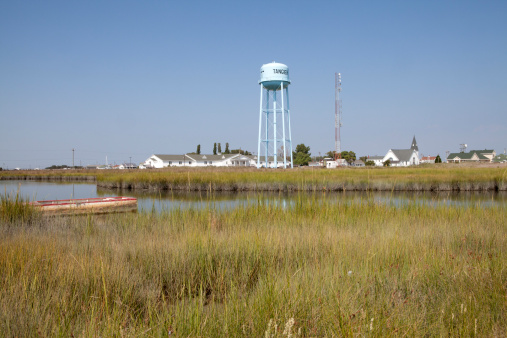
Additionally, the majority of roads on Tangier are projected to be underwater with one foot of sea-level rise.
Nearly one quarter of the Virginia Shore's roads, a total of 371 miles, could be permanently inundated if the sea level rises six feet, as scientists project it could as early as 2090.
Bathtub mapping
The Eastern Shore has more land susceptible to sea-level rise than any other Virginia region, according to the study.
The findings are about stillwater conditions and the report uses "bathtub mapping" of sea-level rise — meaning it does not take into account other ways water levels may increase, such as stormwater and groundwater flooding or storm surge.
The study, funded by NOAA and the Virginia Coastal Zone Management Program, was undertaken last year to help localities and governmental agencies formulate long-range plans for how to deal with the predicted changes.
Among the report's recommendations are that governmental entities consider potential flooding when prioritizing future transportation projects and that the study be updated as new data about sea-level rise becomes available.
"It's within VDOT's current planning horizon and our community's planning horizon," Smith said, adding, "It's important we work with VDOT and try to get out in front of it."
Highway department policy requires an 11-year design horizon for which a secondary road must remain adequate, with a 22-year horizon for some urban secondary roads and other systems, while bridges are planned for a 50-year lifespan — meaning road plans need to take into account projected conditions well into the future.
13News Now Reports: Sea level rise
Most roads leading to communities on the Shore's many necks, along with the Chincoteague and Saxis causeways, were built in the early 1900s with dredged material from nearby wetlands along with materials like oyster shells and timber — materials which could present a challenge when major upgrades to the roads are needed.
When they were built, the sea level was one or more feet lower than it is now.
The study used a NOAA inundation model that describes sea-level rise in ond-foot increments between one to six feet.
Inundation means a road will be flooded during at least one high-tide a day.
"That means at least twice a day you would have to drive through saltwater to get out," Smith said.
The projected dates when different levels of flooding are likely to happen were arrived at using information from a 2013 Virginia Institute for Marine Science study.
The information takes into account data about land subsidence as well as sea-level rise.
"There are a lot of things this allows you to think about that the counties haven't had the capacity to do in the past," for example, when deciding where new development should be located, Smith said.
"They'll be able to think long term — is this a good place for a new community, things like that — looking at it from the standpoint of the roads and accessibility," including for emergency services and the like.
"I'm hoping this gives them the ability to make better-informed decisions," he said.
The study could be used as a model for other regions in Virginia where flooding is a concern.
"This isn't just the Eastern Shore of Virginia ... Everybody's going to be competing for limited VDOT funding ... At some point, they're going to have to figure out a policy," he said.
The Eastern Shore of Virginia Transportation Infrastructure Inundation Vulnerability Assessment will be available on the Virginia Coastal Zone Management Program website.