
Newly-formed Tropical Storm Delta was gaining strength over the Caribbean on Monday, and AccuWeather forecasters are warning that the storm could strike the central Gulf coast of the United States as a powerful hurricane prior to the end of this week.
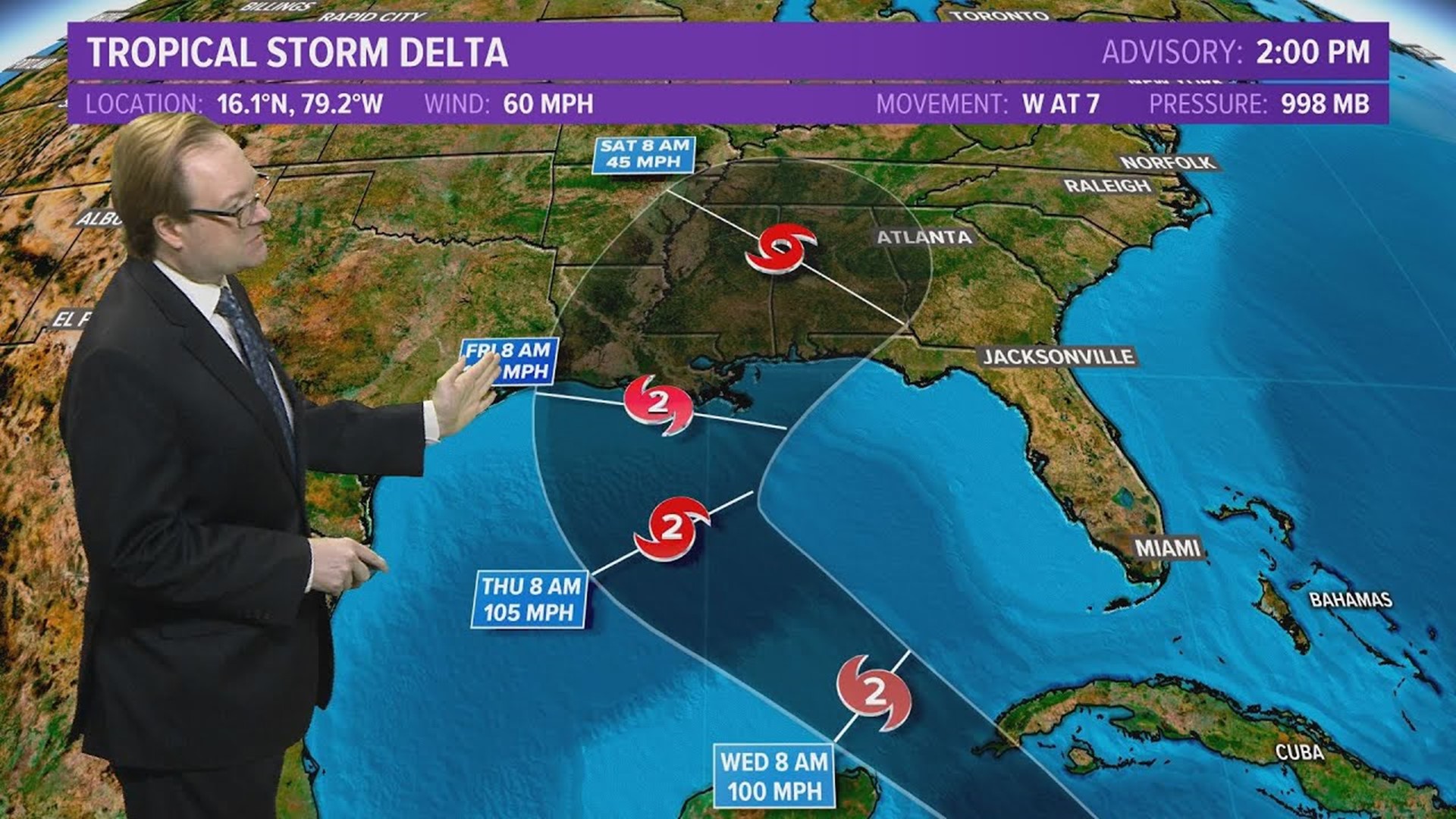
At 2 p.m. EDT Monday, Delta was packing sustained winds of 60 mph with higher gusts and was moving to the west at 7 mph about 165 miles south-southwest of Negril, Jamaica. Hurricane hunters were en route to the storm to investigate its status further, the National Hurricane Center (NHC) said. Satellite imagery showed the storm getting better organized with thunderstorms erupting around its center.
Forecasters urged people and businesses throughout the Gulf of Mexico, and especially along the U.S. central Gulf Coast, to take the threat seriously and closely monitor the storm's progress. The budding storm could gain enough strength to become a Category 2 or major hurricane -- Category 3 or greater -- prior to making landfall in the U.S.
A Category 2 hurricane has maximum sustained winds of 96-110 mph, while a major hurricane has sustained winds of 111 mph or greater.

Delta was upgraded from tropical depression status at 8 a.m. EDT Monday, just over 100 miles south of Jamaica. Delta is the 25th tropical storm of the 2020 Atlantic hurricane season, which continues at a record pace and even well ahead of the notorious 2005 season. The only other season which required the use of Greek letters of the alphabet for storm names was in 2005. Six Greek letters were used that year, and the season concluded with Zeta.
The storm is forecast to strengthen to a strong tropical storm and then a hurricane over the northwestern Caribbean, with winds and seas expected to increase over the central Gulf of Mexico beginning on Tuesday. Surf can become dangerous by the middle of the week through the shoreline of the U.S. Gulf Coast.


Even though Delta is forecast to take a path east of most petroleum rigs in the western Gulf, precautionary shutdowns of the rigs throughout the Gulf are possible due to the forecast strength of the storm and the system could affect refinery operations along the central Gulf coast as well.
As is often the case with hurricanes forecast to make landfall, exact track and strength will determine the severity of impact in the region.
"While there is a chance that wind shear may hold the storm in check at times, there is the potential for Delta to go through a rapid strengthening phase over the northwestern Caribbean and/or the central Gulf of Mexico, due to warm water, if wind shear was to drop off," AccuWeather's top hurricane Dan Kottlowski said.
Wind shear is the increase in wind speed with altitude as well as the sudden change in wind direction from one location to another. Wind shear and changes in the structure of the eye are some of the main challenges in forecasting the overall strength of hurricanes.
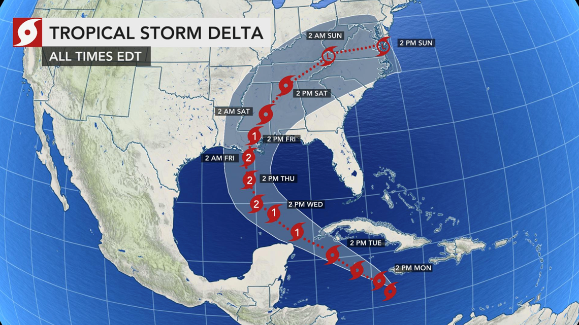
Delta should take a steady path to the northwest into the middle of this week, followed by a northward turn from Wednesday to Thursday over the central Gulf.
Current projections take Delta onshore over southeastern Louisiana on Friday morning, making Delta the first-ever hurricane named after a Greek letter to strike the U.S.
"Since 1964, there have only been three hurricanes to make landfall along the Louisiana coast during October," according to AccuWeather Senior Meteorologist and Forecasting Manager Dan DePodwin.
"Those hurricanes were Lili from 2002, Juan from 1985 and Hilda from 1964," DePodwin said.
There are two major hurricanes that have made landfall along the Louisiana coast in October prior to 1964.
"In 1893, an unnamed storm made landfall near the mouth of the Mississippi River as a Category 4 hurricane with maximum sustained winds of 130-156 mph, and in 1886, an unnamed storm made landfall southwest of Lake Charles as a Category 3 hurricane," DePodwin explained.
Given Delta's current forecast track and strength, AccuWeather StormMax™ winds of 110 mph are forecast for part of southern Louisiana on Friday. But, this could trend higher depending on how much the storm strengthens over the central Gulf.


Fast forward motion may prevent Delta from weakening quickly prior to or upon landfall. The risk of damaging winds can extend well inland and not only result in a significant amount of power outages, but also property damage.
Despite the fact that other storms and hurricanes struck Louisiana and other parts of the Gulf Coast this season, "the Lake Pontchartrain and New Orleans areas have not experienced a major storm surge yet this season," Kottlowski said.


Sally made a sharp northward turn over the Gulf and moved onshore well east of Louisiana, sparing New Orleans the worst in the middle of September. Devastating Hurricane Laura forged a track farther west, crashing ashore over far western Louisiana a few weeks earlier in late August, again taking a path that spared New Orleans the worst flooding.
There is the risk for a significant and dangerous storm surge anywhere to the immediate north and east of where Delta makes landfall.
There is some risk that Gamma, currently a tropical storm near Mexico's Yucatan Peninsula, could remain strong enough to tug on Delta just enough to cause the track to shift. If Gamma were to diminish completely, then Delta's track would undergo little impact from the system.
The track could shift as the storm is still several days away. Should a Category 2 or 3 hurricane move onshore in that area, there is the potential for a significant storm surge in southeastern Louisiana, including on lakes Borgne and Pontchartrain, given current projections.
Delta's fast pace should prevent a repeat of staggering rainfall amounts and flooding from Harvey in 2017 or a lesser extent from Marco, Sally and Beta this year.
A general 4-8 inches of rain is predicted near where Delta makes landfall in the U.S. with an AccuWeather StormMax™ of 12 inches.


Rainfall will tend to diminish as Delta picks up even more forward motion while taking a curved path to the northeast over the southeastern U.S. this weekend. Despite the increasing forward speed, there can still be localized urban and small stream flooding as well as significant rises on the rivers in the storm's path.
Prior to hitting the U.S., Delta will bring torrential rain, locally damaging winds and battering seas to Jamaica, the Cayman Islands, western Cuba and the Isle of Youth through Tuesday.


An AccuWeather Local StormMax™ rainfall of 12 inches, which can lead to flash flooding, and winds will be strong enough to cause property damage and extensive power outages with an AccuWeather Local StormMax™ wind of 80 mph forecast for part of western Cuba and the Isle of Youth.


An AccuWeather Local StormMax™ rainfall of 12 inches, which can lead to flash flooding, and winds will be strong enough to cause property damage and extensive power outages with an AccuWeather Local StormMax™ wind of 80 mph forecast for part of western Cuba and the Isle of Youth.


Once Delta begins to exit the northwestern Caribbean by midweek, an estimate on the RealImpact for the U.S. will be formulated.
Should Delta make landfall in the U.S., it would be 10th storm to do so this season, which will break the current record of nine storms to strike the continental U.S. tied this season and previously set during 1916.
If Delta makes landfall in Louisiana, it would be the fourth storm to do so this season. Cristobal was the first of the storm, crashing into southeastern parts of the state as a tropical storm in June, followed by Category 4 Hurricane Laura and Tropical Storm Marco, both in August.


Cristobal, as well as every named storm from Edouard through Delta, set early-formation records. Most of the previous record-holders were storms from the 2005 season. Delta from this year knocked off the 25th storm from 2005 that was named Gamma. In 2005, Gamma did not form until Nov. 18. There was a prior unnamed storm in 2005 that was later just identified as the Azores subtropical storm, which shifted the number of named storms on the list by one.