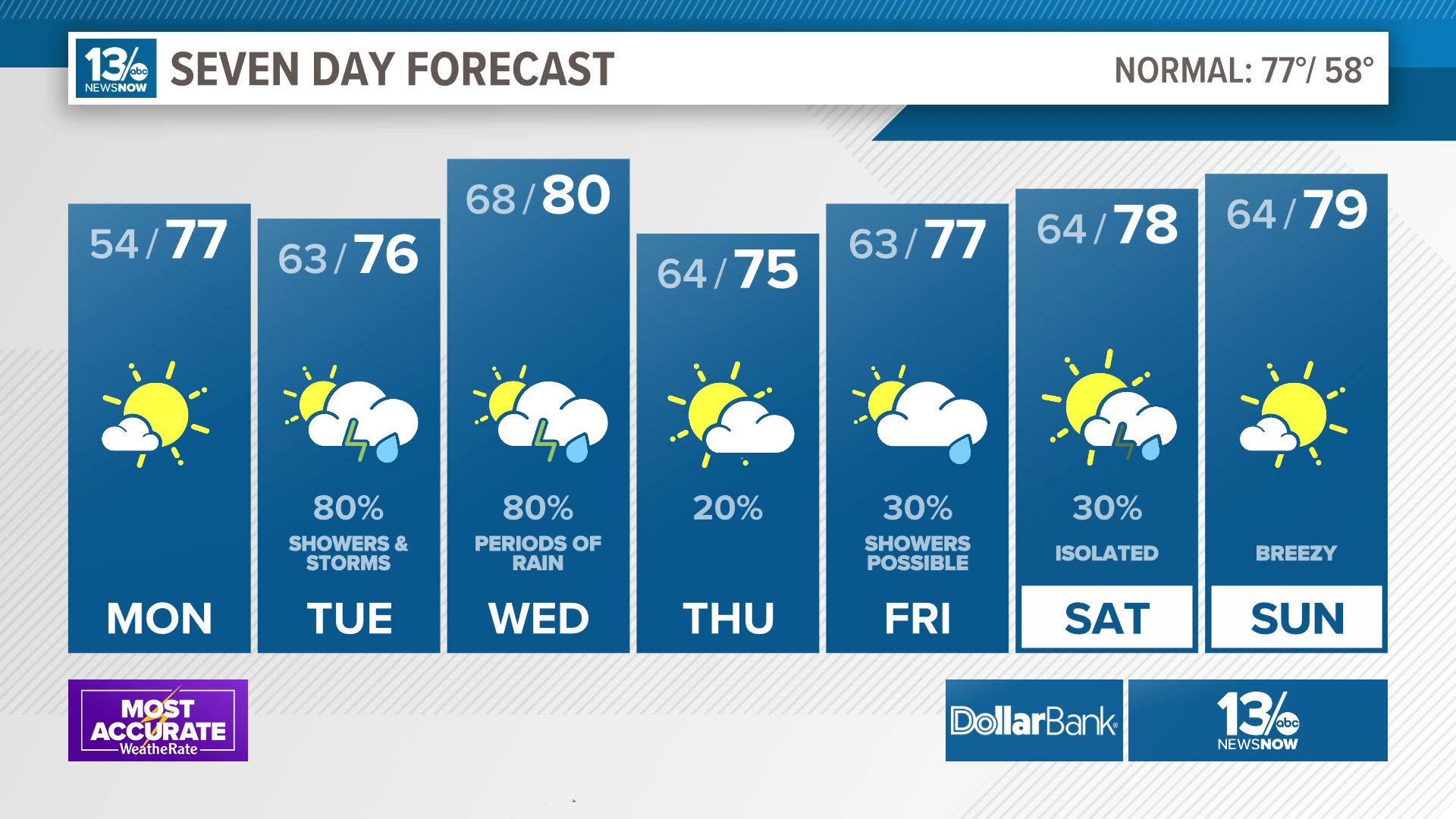
x
Breaking News
More () »

FORECAST: More clouds, showers and breezy weather to end the week

Brighter days late this weekend into next week.

NORFOLK, Va. — A stubborn area of low pressure off the Carolina coast will continue to give cloudy and cool weather to the region through the start of the weekend. But signs of improvement show up by the second half of the weekend. 

It will be cloudy overnight with more light rain and drizzle. Cloud cover will keep temperatures in the 60s overnight.

Friday will be similar to Thursday with isolated rain showers becoming more minimal by Friday night. High temperatures will be in the lower 70s.

Credit: 13News Now
A look at the Friday forecast.

Tides will still run high Friday, and a Coastal Flood Advisory is in effect through Friday afternoon.

Credit: 13News Now
A coastal flood advisory is in effect for Virginia cities and counties along the Chesapeake Bay and its tidal tributaries.

We came through the Thursday evening high tide right around 5.0', and Friday's tides should be a little bit lower.

Credit: 13News Now
Tides at Sewells Point

It will be more of the same for a good part of the day Saturday, with cloudy skies and a few showers. Highs will once again be in the lower 70s.

Improving weather and a clearing trend finally takes place later Saturday, and especially Sunday, as the stubborn low pressure center finally pushes out to sea and high pressure builds in. We will be in the middle 70s on Sunday.

Next week looks to be sunnier, with seasonable temperature in the middle to upper 70s.

TROPICS

In the tropics, we have two tropical storms that are relatively close to each other, east of the Lesser Antilles. 

Credit: 13News Now
Forecast track and intensity for Tropical Storm Philippe.

Tropical Storm Philippe is drifting west-southwest. Philippe's fate is uncertain, since it is so close to Tropical Storm Rina to its east. If Philippe were to manage to survive beyond five days, it could strengthen later next week. 

Credit: 13News Now
Forecast track and intensity for Tropical Storm Rina.

Tropical Storm Rina formed earlier Thursday and is forecast to hold steady and move to the northwest. Due to interaction with nearby Philippe, there is some uncertainty in Rina's strength down the road. But both Philippe and Rina post no immediate threat to land.

Share weather photos and video here

Download the 13News Now App

Stay connected 24/7 via 13News Now

13News Now Weather Page

13News Now Facebook Page

13News Now on Twitter @13NewsNow

13News Now on YouTube

13News Now on Instagram

Before You Leave, Check This Out