
WASHINGTON — The 2024 Atlantic hurricane season is expected to be busy, and the National Oceanic and Atmospheric Administration (NOAA) issued the highest pre-season outlook in its history.
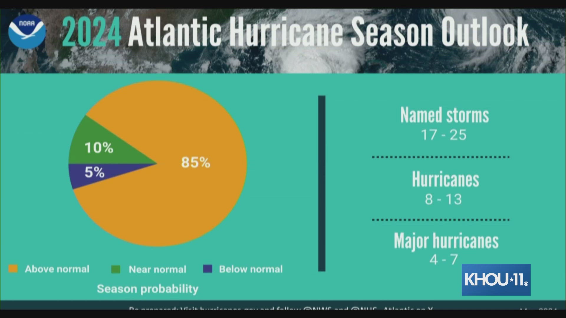
NOAA forecasters spoke Thursday morning in Washington, D.C., providing details about what is expected this season, saying there's an 85% chance that the Atlantic hurricane season that starts on June 1 will be above average in storm activity.
After seeing record-warm ocean surface temperatures, a high probability of La Nina during peak hurricane season, and other factors, forecasters predict the following activity for the 2024 Atlantic hurricane season:
- 17-25 named storms (average is 14)
- 8-13 hurricanes (average is 7)
- 4-7 major hurricanes (Category 3 or higher) (average is 3)
Forecasters said this is the highest NOAA has ever issued for a May outlook. An average Atlantic hurricane season produces 14 named storms, seven of them hurricanes and three major hurricanes.
"The upcoming Atlantic hurricane season is expected to have above-normal activity due to a confluence of factors, including near-record warm ocean temperatures in the Atlantic Ocean, development of La Nina conditions in the Pacific, reduced Atlantic trade winds and less wind shear, all of which tend to favor tropical storm formation," said NOAA's statement, in part.
“This season is looking to be an extraordinary one in a number of ways,” NOAA Administrator Rick Spinrad said. He said this forecast is the busiest that NOAA has seen for one of their May outlooks; the agency updates its forecasts each August.
"All the ingredients are definitely in place to have an active season," National Weather Service Director Ken Graham said. "It’s a reason to be concerned, of course, but not alarmed."
Forecasters say now is the time to prepare, saying it "only takes one storm to devastate a community."
What people should be most concerned about is water because 90% of hurricane deaths are in water and they are preventable, Graham said.
When meteorologists look at how busy a hurricane season is, two factors matter most: ocean temperatures in the Atlantic where storms spin up and need warm water for fuel, and whether there is a La Nina or El Nino, the natural and periodic cooling or warming of Pacific Ocean waters that changes weather patterns worldwide. A La Nina tends to turbocharge Atlantic storm activity while depressing storminess in the Pacific and an El Nino does the opposite.
La Nina usually reduces high-altitude winds that can decapitate hurricanes, and generally during a La Nina there's more instability or storminess in the atmosphere, which can seed hurricane development. Storms get their energy from hot water. Ocean waters have been record warm for 13 months in a row and a La Nina is forecast to arrive by mid to late summer. The current El Nino is dwindling and is expected to be gone within a month or so.
“We've never had a La Nina combined with ocean temperatures this warm in recorded history so that's a little ominous,” said University of Miami tropical meteorology researcher Brian McNoldy.
This May, ocean heat in the main area where hurricanes develop has been as high as it usually is in mid-August. "That's crazy,” McNoldy said. It's both record warm on the ocean surface and at depths, which “is looking a little scary.”
He said he wouldn't be surprised to see storms earlier than normal this year as a result. Peak hurricane season usually is mid-August to mid-October with the official season starting June 1 and ending Nov. 30.
A year ago, the two factors were opposing each other. Instead of a La Nina, there was a strong El Nino, which usually inhibits storminess a bit. Experts said at the time they weren't sure which of those factors would win out.
Warm water won. Last year had 20 named storms, the fourth-highest since 1950 and far more than the average of 14. An overall measurement of strength, duration and frequency of storms had last season at 17% bigger than normal.
Record hot water seems to be key, McNoldy said.
“Things really went of the rails last spring (2023) and they haven't gotten back to the rails since then,” McNoldy said.


“Hurricanes live off of warm ocean water,” said Colorado State University hurricane researcher Phil Klotzbach. “That tends to basically be fuel for the hurricane. But also when you have the warm Atlantic what that tends to do is also force more air up over the Atlantic, more rising motion, which helps support strong thunderstorms.”
There's the background of human-caused climate change that's making water warmer in general, but not this much warmer, McNoldy said. He said other contributors may include an undersea volcano eruption in the South Pacific in 2022, which sent millions of tons of water vapor into the air to trap heat, and a reduction in sulfur in ship fuels. The latter meant fewer particles in the air that reflect sunlight and cool the atmosphere a bit.
Seven of the last 10 Atlantic hurricane seasons have been more active than the long-term normal.
Climate change generally is making the strongest hurricanes even more intense, making storms rain more and making them rapidly intensify more, McNoldy said.
This year, Colorado State University — which pioneered hurricane season forecasting decades ago — is forecasting a season that's overall 71% stronger and busier than the average season with 23 named storms and 11 hurricanes.
That's at “levels comparable to some of the busiest seasons on record,” said Klotzbach.
Klotzbach and his team gave a 62% probability that the United States will be hit with a major hurricane with winds of at least 111 mph. Normally the chance is 43%. The Caribbean has a two-out-of-three chance of getting hit by a major hurricane and the U.S. Gulf Coast has a 42% likelihood of getting smacked by such a storm, the CSU forecast said. For the U.S. East Coast the chance of being hit by a major hurricane is 34%.
Klotzbach said he doesn't see how something could shift soon enough to prevent a busy season this year.
“The die is somewhat cast,” Klotzbach said.