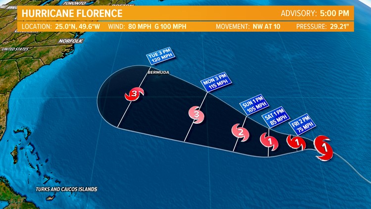
Yesterday Hurricane Florence gained intensity far more quickly than any computer (or forecaster) had expected. Experts are not sure why that happened but we think that there was a pocket of calmer upper level winds within a large area of gusty winds that had been expected to keep Florence from strengthening. At its peak Florence reached category 4 status out of 5. Anything over a 3 is considered a major hurricane.


The forecast track prediction remains difficult in the extended period. So far the track has been pretty close to what was expected because it has been a very straightforward pattern in the atmosphere.
However, the pattern will change in a big way in a few days. A cold front will start to draw Florence toward it but the big question is whether or not it will be strong enough to maintain its grip on the hurricane and keep it moving out to sea.
When a front just barely gets a grip on a hurricane it will start to pull it in and then lose its grip. That allows the storm to drop back and wait for the next front. Sometimes if high pressure moves in behind the cold front it can stop a storm from advancing, and push it off to the west into the East Coast. When you look at past storm tracks and notice complete loops that is what happened.
One thing that meteorologists like to do is to look at past history. If a storm has always moved toward a specific area after being in a certain position in the Atlantic then we have to take that into account.
The same thing goes for a storm that is in a specific position but has never headed somewhere (like into Hampton Roads). If you look at all the storms in recorded weather history no storm has ever been as far north as Florence and hit near Hampton Roads. Yesterday the only storm that had ever hit us from where Florence was located was Isabel. Today Florence is north of where Isabel was and there are no analogs for a storm from this location to hit us. However, we must remember that every storm is different and the upper level pattern with Florence is looking a bit more favorable for a threat to the East Coast versus a "normal" storm in the position where it is now. In fact, the odds are starting to favor a storm that at least makes a run at the East Coast.

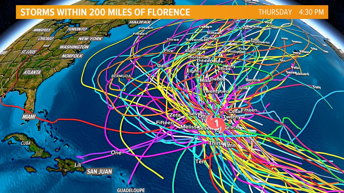
Another major factor when looking at the difference between Isabel and Florence is that the upper-level winds ahead of Isabelle did not change much, and the forecast even from as much as a week ahead of time was very consistent. In this case, we do not have that. One model run will show a cold front picking up the storm and keeping it harmlessly out to sea, only to be followed 12 hours later by the same model showing the cold front losing its grip on Florence and the following area of high pressure pushing the storm back near us.
One thing I want to talk about is models versus model ensembles.
Normally when you hear us talking about computer models we are referencing a specific model that was run one time: like the GFS, Euro, NAM, HWRF, UKMET, etc. When we talk about ensembles we are talking about running one model many times and then taking the average.
For example, the GFS model has been run every day for Florence and always shows the storm staying offshore from Hampton Roads. When it gets run dozens of times it produces very different solutions. Sometimes the average of those solutions turns out to be better than the run that was only done once. In this case, the latest run shows a red line which is the single run and keeps Florence far enough offshore that we would not get too many major effects. The other runs average out to be the blue line that is shown. It should be noted that the trend with the GFS has been a bit west with each new run.


The same thing happens with the Euro model (or ECMWF). It has been the best performing hurricane model for several years. Here is a graphic showing the single run (the thinner gold line) and the rest of the runs in yellow. The average of all the runs is not shown here is shown as a slightly thicker gold line and shows a powerful storm that stays just offshore instead of making landfall.


So, the bottom line is that in a pattern as sketchy as this one and that is changing as much as this one is, there is no way to tell where Florence is heading. It will probably be at least 3 more days until we can pin down what is most likely to happen here in Hampton Roads. Since we are entering the peak of hurricane season and things are starting to be very active you should make your plans now for what to do if a hurricane strikes Hampton Roads, and hope that you don’t have to use them.
► Make it easy to keep up to date with more stories like this. Download the 13News Now App.