
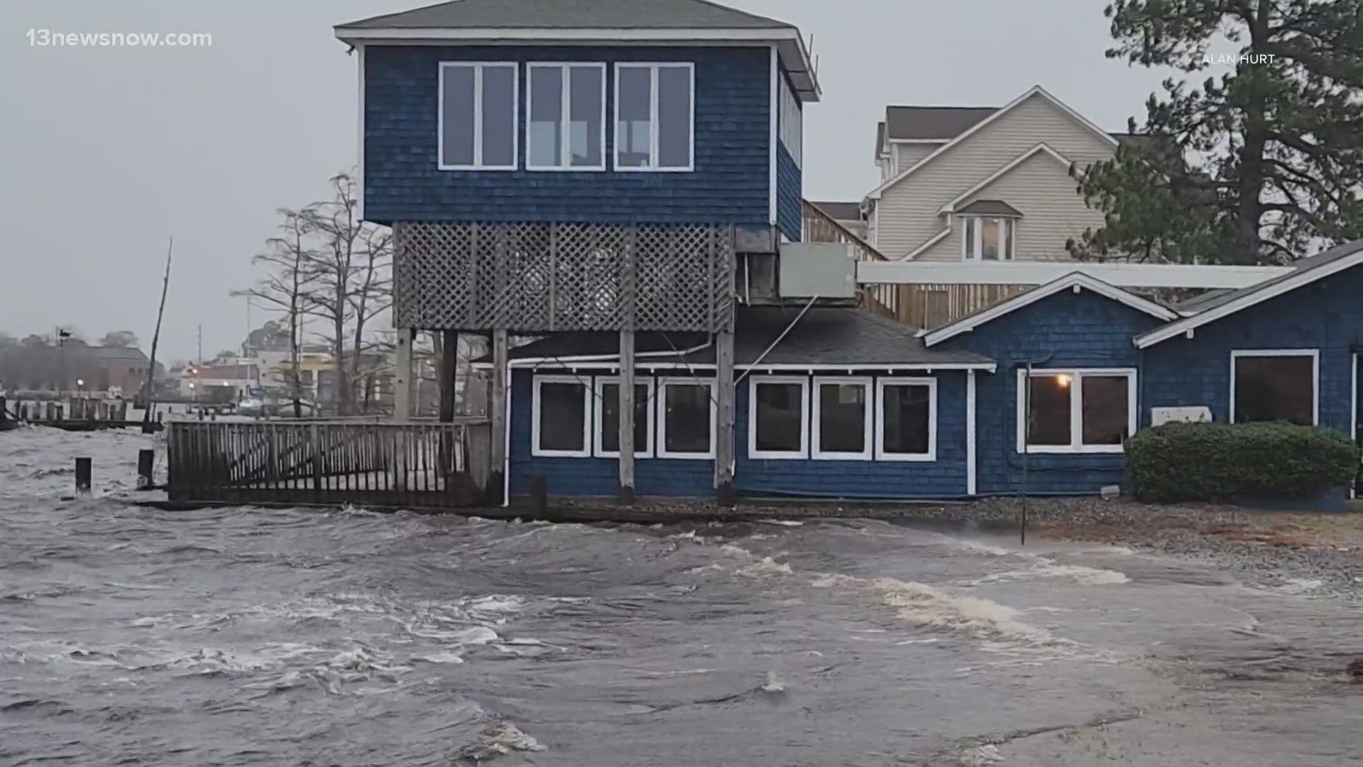
NORFOLK, Va. — Severe weather is in the forecast for Hampton Roads and northeastern North Carolina with heavy rain and strong wind expected Tuesday afternoon into the evening.
The main threat is wind up to and possibly exceeding 60 miles per hour, which will gradually get stronger as Tuesday progresses. There is also a low tornado risk and two to three inches of rain is expected.
Light to moderate showers will develop across most of Hampton Roads in the middle of the morning, but the threat of potentially strong to severe thunderstorms grows into the evening hours. The timing of the severe weather is between 3 and 10 p.m., but it is subject to change.
Follow 13News Now as track updates across Hampton Roads and northeastern North Carolina:
9:25 p.m. — Flash flood warning issued for part of Hampton Roads
A Flash Flood Warning is in effect for much of Hampton Roads until 3:15 a.m. It covers Chesapeake, Norfolk, Portsmouth and Virginia Beach.
Flash floods are likely in areas where there are small creeks, streams, urban areas, highways, streets, underpasses and other poor drainage and low-lying areas
Officials remind drivers who come across standing water to "turn around, don't drown," saying the majority of flood-related deaths happen inside a vehicle.
9:00 p.m. — Tornado Watch extended for much of Hampton Roads
The Tornado Watch has expired for the western part of our area, but it has now been extended to 11 p.m. for most of Hampton Roads. It was previously set to expire at 9.
So far, no Tornado Warnings have been issued tonight.
8:30 p.m. — Severe thunderstorm warning issued for part of Hampton Roads
The National Weather Service (NWS) issued a severe thunderstorm warning for Norfolk, Chesapeake and Newport News. It is in effect until 9:30 p.m.
8:10 p.m. — NC12 remains open, but driving conditions are still poor
NCDOT reports that NC12 on the Outer Banks has made it through high tide with no ocean overwash and that it is currently open.
However, officials strongly recommend not driving tonight unless absolutely necessary, as winds remain strong and are expected to get stronger, which also means wet sand is blowing onto the highway.
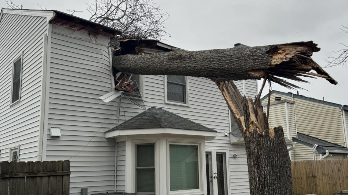
7:45 p.m. — 2 displaced after tree falls on Chesapeake house
Captain Steve Bradley said Chesapeake Fire Department crews were dispatched to the 1500 block of Debbs Lane Tuesday afternoon when a tree fell onto a house.
There were people inside the Greenbrier-area home when the storm damage happened, around 3:45 p.m., but no one was injured, Bradley said. Two people have been displaced from the residence.

7:45 p.m. — Severe thunderstorm warning for parts of Virginia Peninsula, Middle Peninsula and Northern Neck
Parts of the Virginia Peninsula, Middle Peninsula and Northern Neck are under a severe thunderstorm warning until 8:15 p.m. The warning includes Gloucester, Middlesex, Northumberland, Charles City, New Kent, James City, Essex and Lancaster counties.
7:40 p.m. — Severe thunderstorm warning west of Hampton Roads; includes Southampton County, Virginia
The National Weather Service issued a Severe Thunderstorm Warning for Northampton and Hertford counties in North Carolina, and Greensville and Southampton counties in Virginia until 8:15 p.m.
7:30 p.m. — More than 27,000 Dominion Energy customers without power in southeast Virginia
27,519 Dominion Energy customers are without power in the southeastern region of Virginia. Here's a breakdown of customers without power by city:
- Chesapeake: 8,992
- Hampton: 149
- Isle Of Wight: 2,868
- James City: 51
- Newport News: 5,577
- Norfolk: 1,064
- Poquoson City: 2,161
- Portsmouth: 3,691
- Suffolk: 805
- Surry: 584
- Virginia Beach: 1,311
- Williamsburg: 0
- York: 266
To stay up-to-date on outages and how to report power loss, visit Dominion Energy's website or call 866-366-4357.
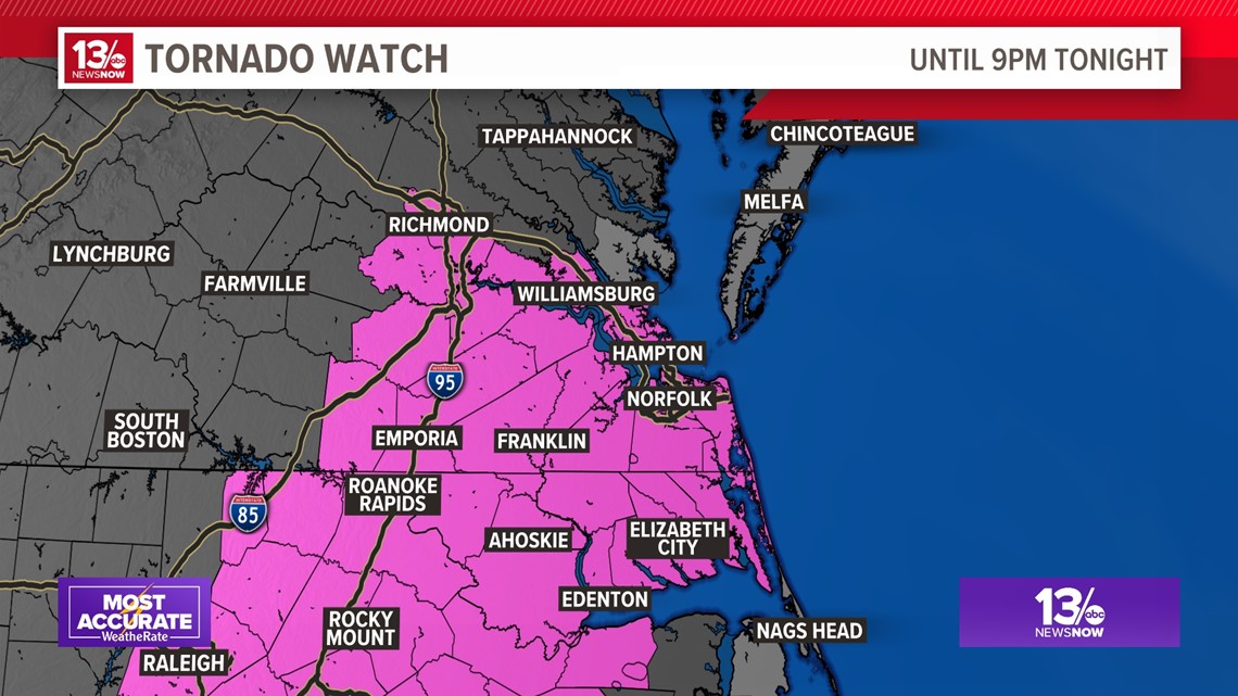
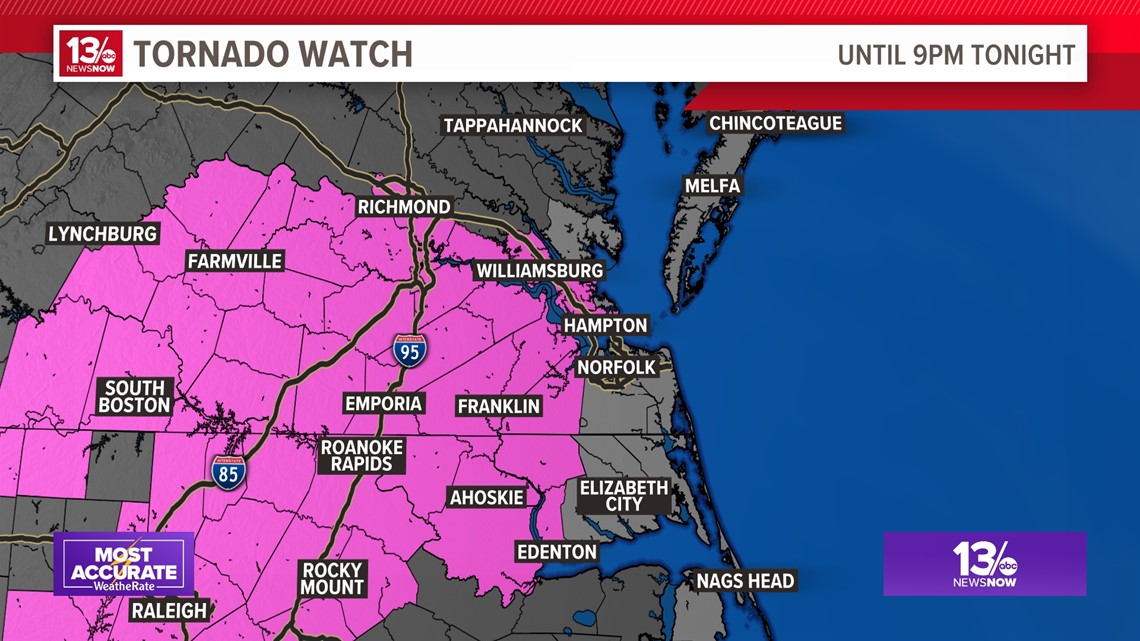
7:15 p.m. — All of Hampton Roads under tornado watch until 9 p.m.
The National Weather Service once again expanded its tornado watch eastward to include the entire Hampton Roads region, as well as northeast North Carolina.
The watch now includes Chesapeake, Norfolk, Portsmouth and Virginia Beach. In North Carolina, Elizabeth City, and Camden, Currituck, Pasquotank and Perquimans counties are also under the watch.

7 p.m. — Severe thunderstorm warning issued west of Hampton Roads; includes Emporia, Southampton County
The National Weather Service issued a severe thunderstorm warning west of the Hampton Roads region. It will expire at 7:45 p.m.
The warning includes the city of Emporia, and Southampton, Prince George, Sussex, Dinwiddie and Brunswick counties in Virginia.
5:55 p.m. — Tornado watch expands eastward, now covers parts of Hampton Roads
The National Weather Service expanded a tornado watch covering much of southern Virginia to include parts of Hampton Roads and northeastern North Carolina. The watch lasts until 9 p.m. Tuesday.
In Virginia, the watch includes Franklin, Hampton, Newport News, Suffolk and Williamsburg, and Isle of Wight, James City, Southampton, Surry, Sussex and York counties. In North Carolina, the watch includes Bertie, Chowan, Gates and Hertford counties.
A tornado watch means weather conditions are favorable for thunderstorms capable of developing tornados within a certain area.

5:50 p.m. — Turn around, don’t drown
Tuesday's heavy rain is a good reminder to turn around and don't drown when the roads are flooded.
13News Now Reporter Emily Harrison shared a video of one person who misjudged the depth of the water in Elizabeth City, North Carolina.
5:30 p.m. — Heaviest rain, strongest winds will be between 7 and 11 p.m.
The worst of the severe weather will be between 7 and 11 p.m. Tuesday as the cold front moves through. This is when we will see some of the heaviest rain and strongest winds.
So far, there have already been wind gusts of more than 60 miles per hour at NAS Oceana in Virginia Beach, and more than 50 miles in Norfolk.
3:45 p.m. — CBBT now at Level 2 wind restrictions
The Chesapeake Bay Bridge-Tunnel is now at Level 2 wind restrictions. That means the only vehicles allowed to cross are cars without exterior cargo, pick-up trucks (to include 2-axle, 6 wheels) without cargo, mini-vans, vans not to include high-profile/conversion vans, and SUVs. For more on the CBBT's different wind restrictions, visit their website.
3:30 p.m. — Coast Guard urges boaters across Mid-Atlantic region to be safe during storm
With strong winds expected across the Mid-Atlantic region, the Coast Guard is urging boaters to stay safe.
"Sustained southeast winds between 25 and 35 mph are anticipated in the area, resulting in hazardous marine conditions," officials wrote in a news release Tuesday afternoon. "These conditions create life-threatening beach hazards, including dangerous rip currents and large battering waves."
To be safe, the Coast Guard encourages boaters to stay off the water, secure their belongings and monitor the storm on VHF radio channel 16.
3:20 p.m. — Dominion Energy urges residents to brace for outages amid severe weather
Dominion Energy is warning customers to brace for the possibility of multi-day restoration efforts following Tuesday's severe weather.
With thunderstorms and exceeding 60 mph wind gusts expected, Dominion Energy is anticipating tree damage and down powerlines leading to widespread outages.
The utility company has deployed hundreds of crews across Hampton Roads, Gloucester, the Outer Banks, and several other counties in North Carolina.
2:45 p.m. — CBBT under wind restrictions
The Chesapeake Bay Bridge-Tunnel is currently operating with Level 1 wind restrictions. That means the speed limit on the bridge-tunnel is 45 mph and no passing is allowed. For more on the CBBT's different wind restrictions, visit their website.
1:45 p.m. — Tornado watch issued for southern Virginia, central North Carolina
The National Weather Service issued a tornado watch for much of the south-central part of Virginia and central North Carolina until 9 p.m. EST.
11:45 a.m. — Virginia at yellow emergency level, Gov. Youngkin says
Virginia Gov. Glenn Youngkin said in an X post that the Virginia Emergency Support Team (VEST) will remain at a yellow status level, meaning state officials will have an increased readiness and monitoring.
"Stay alert and informed by following the latest forecasts and I ask all Virginians to be vigilant in their travel today," Youngkin wrote.
School closures across Hampton Roads, Coastal Virginia due to severe weather threat
Because the timing of the severe weather is between 3 and 10 p.m., many schools in the region are dismissing early and many after-school activities are canceled.
Tap or click here for a full list of school closures across southeastern Virginia and northeastern North Carolina.