
NORFOLK, Va. — When I started as a professional meteorologist in 1980, long-range hurricane forecasts from the National Hurricane Center (NHC) went out three days, or 72 hours. It would be over 20 years before four and five-day forecasts started being issued. During that time, the average error improved greatly which is shown in the following graphic.
In 1980, the average forecast error for location was 125 miles just 24 hours ahead of time. The two-day forecast was off an average of 275 miles, and the three-day average was a whopping 400 miles!

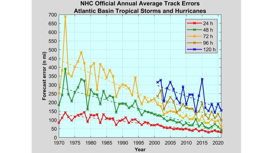
By the time we started issuing four and five-day forecasts, the very first five-day error was better than the three-day average had been back in 1990. Forecasts kept improving and by 2020, the average error at five days was better even than the three-day forecasts from 2005.
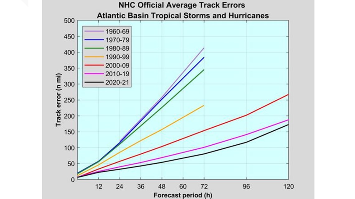
In the 2nd graphic, you can see that the five-day average error in 2020 and 2021 was about the same as the average error in the 1990s (yellow line) at just 2 days out (48 hours):

Forecasting the intensity of hurricanes has also gotten better over the years, although the improvements have come a little more slowly than have the track forecasts.
In 1992 a three-day forecast was off by an average of almost 30 miles per hour in the wind speeds. By 2020, the one-day forecast error was down to about 7 miles per hour, the three-day was usually off by about 12 miles per hour, and the five-day wind speeds were off by under 15 mph. That was equal to the two-day forecasts from about 2008.
Another interesting note is that the margin of error does not necessarily mean the forecast was wrong about where a storm would hit. In many cases it was the timing that was off, meaning the storm would be hundreds of miles short of its projected location on day five, only to then pass over that exact location at some later time because the track forecast was accurate, just a little fast or slow.
Here is another way to think about it. Say you are going to drive from Hampton Roads to California and you estimate that it will take you five days if you go the exact speed limit on every road you have planned to take. You don’t know it but your speedometer is off by just 2% from a perfect calibration. That 2% by the end of the trip will mean you will be off by hours from your expected arrival.
The same thing happens with hurricanes. They get pushed along by the winds in the atmosphere. Over land, we know what the winds are in all the locations where we send up weather measurement balloons twice per day, but we don’t have the same data over the oceans. We estimate the winds using various methods, but even a small difference gets magnified over several days and causes errors in the track verification, but not always in the accuracy of the track itself, just the timing.
A hurricane could have the average error as it approaches Hampton Roads and be 150 miles offshore when it was predicted to be over us, but then move on to the exact predicted track a day later and be over us.
I have never seen any data on what the average distance a hurricane makes landfall in the US versus where it was supposed to when you only account for distance and not time. I can bet that it is a LOT smaller than the average track errors that I mentioned at the beginning of the article.