
NORFOLK, Va. — Weather Alert Day has expired as storms move out of Hampton Roads on Monday evening.
A strong cold front approached Hampton Roads, bringing the potential for damaging winds and lightning.
Breezy southerly winds transported a hot, humid air mass into the region helping to create an unstable environment conducive for strong to severe thunderstorms. The trigger to ignite any storms will be the arrival of the cold front.
With Monday being Memorial Day, many will be spending time outdoors at various events or at the beach. Despite uncertainty please be aware of the potential for severe weather and have an indoor plan in place. All hazards of severe weather are possible. Gusty, damaging winds, heavy rainfall, frequent lightning, hail and even an isolated tornado.
Due to this, the 13News Now Weather Team declared Memorial Day, Monday, May 27, a Weather Alert Day.
Potential impacts included gusty and damaging winds that could reach between 50 and 60 mph, frequent lightning and heavy rainfall, possible hail, and a chance of isolated tornadoes.
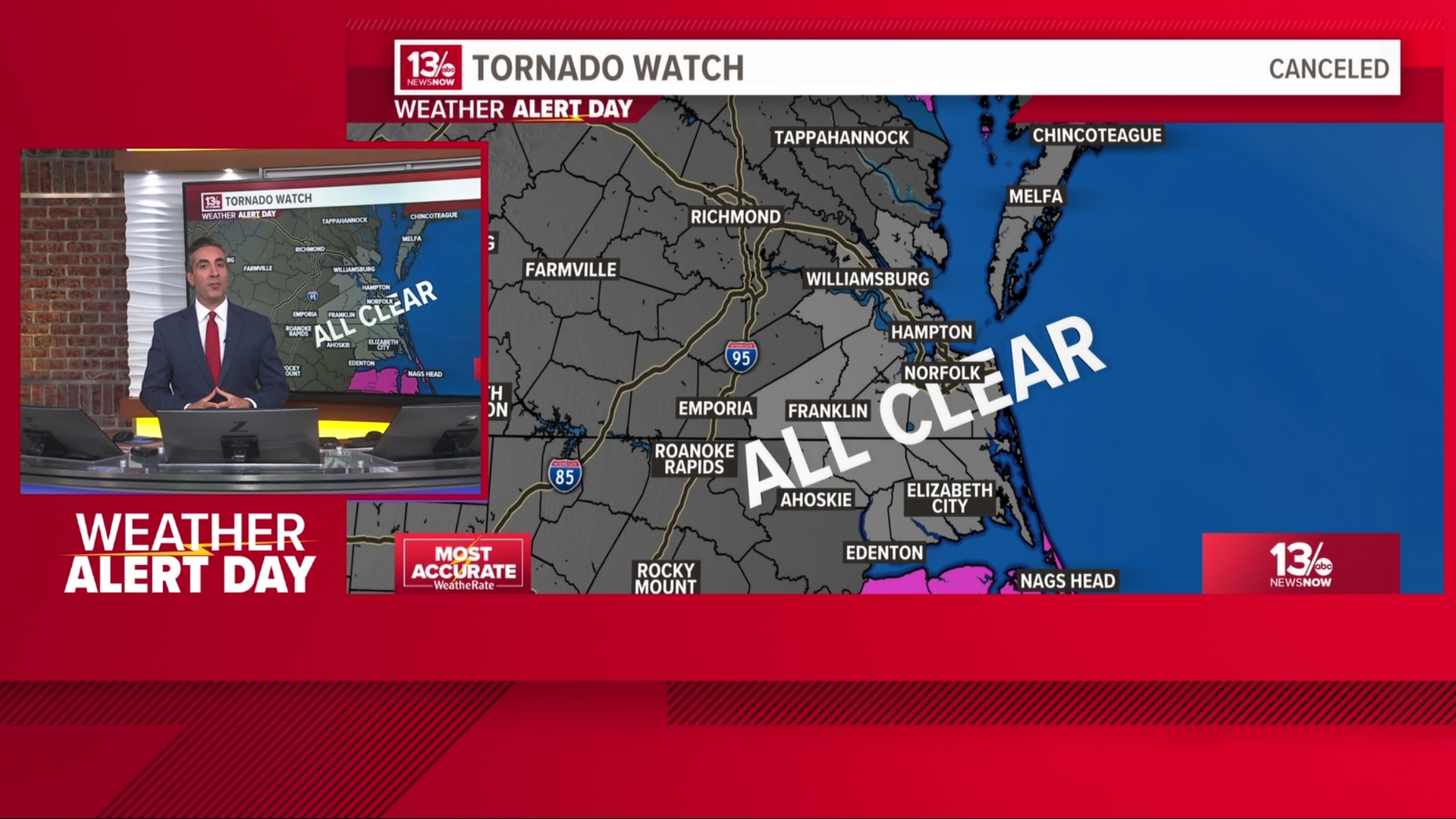
8:30 p.m. — Tornado watch canceled for Hampton Roads
The tornado watch has been canceled. The severe threat for Hampton Roads is over.
7:30 p.m. — Tornado warning expires for northeastern North Carolina
The tornado warning issued for Camden, Currituck and Pasquoatank counties has expired. However, a tornado watch still remains in effect until 11 p.m.
7 p.m. — Storms knock out power for thousands
Dominion Energy reports more than 3,800 customers are without power across Hampton Roads, with the largest outage in Norfolk where there is nearly 2,500 customers are experiencing an outage.
Over in North Carolina, nearly two dozen customers in Bertie County and two in Perquimans County are reporting they have lost power.
6:45 p.m. — Multiple North Carolina counties under tornado warning
A tornado warning, which is in effect until 7:30 p.m., encompasses part of northeastern North Carolina, including Camden, Currituck and Pasquotank counties.
6:30 p.m. — Another severe thunderstorm warning for Southside
A severe thunderstorm warning was issued for Chesapeake and Virginia Beach until 7:30 p.m.
6:05 p.m. — Southside Hampton Roads under severe thunderstorm warning
Much of the Southside and the Peninsula are under a severe thunderstorm warning, including Norfolk, Virginia Beach, Hampton, Newport News, Portsmouth, Suffolk, Chesapeake and Poquoson.
The warning expires at 6:45 p.m.
5:35 p.m. — New warnings in Virginia, North Carolina
The National Weather Service has issued two severe thunderstorm warnings in the region.
North of Hampton Roads, a severe thunderstorm warning is in effect for Gloucester, King and Queen, York and James City counties until 6:15 p.m.
In North Carolina, a warning is in effect for Camden, Pasquotank, Perquimans, Bertie, Hertford, Gates and Chowan counties until 6:30 p.m.
5:20 p.m. — Severe thunderstorm warning issued for Peninsula, Isle of Wight
Much of Hampton Roads is under a severe thunderstorm warning until 6 p.m.
The warning includes Poquoson, Suffolk, Hampton and Newport News, along with Isle of Wight and York counties. As of 5:19 p.m., the storm was over Isle of Wight moving northeast at 30 miles per hour, according to the National Weather Service.
The main threat is wind gusts reaching 60 miles per hour.
5:20 p.m. — Tornado warning issued for Pitt, Martin counties in North Carolina
The National Weather Service issued a tornado warning for Pitt and Martin counties in northeastern North Carolina.
The warning lasts until 5:45 p.m. with the storm moving east at 20 miles per hour.
5 p.m. — Severe thunderstorm warnings move closer to Hampton Roads
In Virginia, the city of Franklin, Southampton County and Isle of Wight County are under a severe thunderstorm warning until 5:45 p.m. The storm is moving northeast at 25 miles per hour with wind gusts and hail being the main threats.
The National Weather Service has also issued a severe thunderstorm warning for several North Carolina counties in 13News Now's viewing area.
The warning expires at 5:45 p.m. and includes Bertie, Northampton, Hertford and Gates counties. The storm is moving east at 40 miles per hour, according to the National Weather Service.
4:40 p.m. — Severe thunderstorm warning west of Hampton Roads
With storms firing up west of Hampton Roads, another severe thunderstorm warning has been issued in south central Virginia.
The warning includes Greensville, Southampton and Sussex counties, as well as the city of Emporia, and lasts until 5:30 p.m. According to the National Weather Service, 60-mile-an-hour winds and quarter-sized hail are the main hazards.
4:10 p.m. — Severe thunderstorm warnings issued along Virginia-North Carolina state line
Several warnings have been issued along Virginia and North Carolina's state lines.
A severe thunderstorm warning is in effect for Southampton and Greensville counties in Virginia, and Northampton County in North Carolina, until 4:45 p.m. The National Weather Service also issued a warning for Bertie and Northampton counties in North Carolina that lasts until 5 p.m.
A tornado warning was issued for Edgecombe and Halifax counties in North Carolina until 5 p.m.
3:55 p.m. — 1 tornado warning in effect in Halifax County, North Carolina
Just outside the 13News Now viewing area, a tornado warning is in effect for Halifax County, North Carolina until 4:30 p.m.
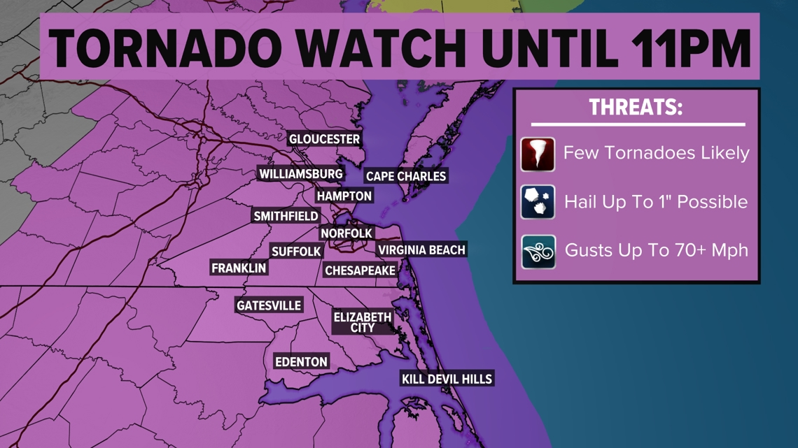
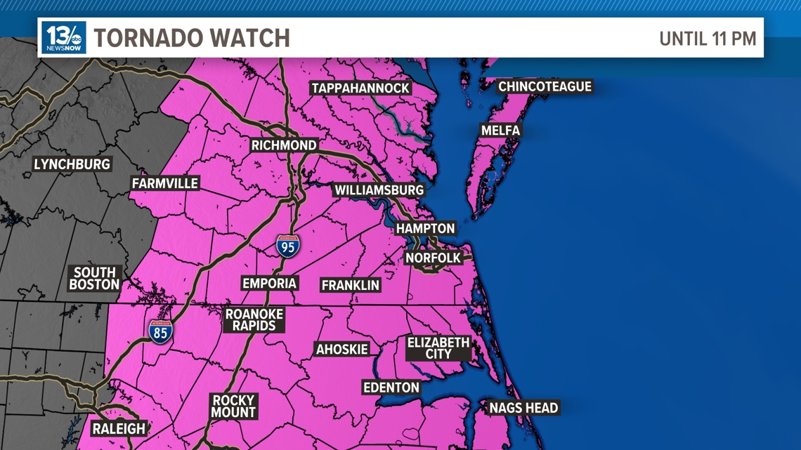
3:40 p.m. — Tornado watch issued for much of Virginia, North Carolina
The National Weather Service has issued a tornado watch for eastern Virginia and North Carolina until 11 p.m.
In Virginia, the watch includes all of Hampton Roads, the Eastern Shore and the Interstate 95 corridor. The watch also spans eastern North Carolina, including the Outer Banks.
A watch means tornadoes are possible in and near the watch area. People under a tornado watch should be prepared for when a warning is issued.


3:30 p.m. — Storms to develop over the next several hours as atmosphere recharges
Following a brief round of rain and thunderstorms earlier Monday, 13News Now's Weather Team is tracking another system building southwest of the Hampton Roads region.
According to Chief Meteorologist Tim Pandajis, breaks in the cloud cover are causing the atmosphere to destabilize, resulting in storms popping up along the corridors of Interstates 85 and 95 in Virginia and North Carolina. Those storms are moving east-northeast, which will impact southeastern Virginia and northeastern North Carolina.
Pandajis also noted the dew points in Hampton Roads, which he described as a tropical air mass in place.
"With emerging sunshine across the area right now, think of the atmosphere as a pot of very hot water and all you need to make it boil is to turn the burner back on, the sun," Pandajis explained during his 3:30 p.m. forecast update. "We are going to immediately see the atmosphere destabilize."
Pandajis said a cold front currently off the west will trigger the storms as it barrels into the unstable air mass.
2 p.m. — Severe thunderstorm warning expires
A severe thunderstorm warning expired at 2 p.m. for much of northeastern North Carolina and parts of southeastern Virginia, including Chesapeake and Virginia Beach.
Follow 13News Now for the latest weather updates.
1:25 p.m. — Severe thunderstorm warning issued for part of coastal Virginia, North Carolina
The National Weather Service issued a severe thunderstorm warning for much of northeastern North Carolina and parts of southeastern Virginia, including Chesapeake and Virginia Beach. The warning is in effect until 2 p.m.
During the warning, NWS warns there is potential for wind gusts of up to 60 miles per hour and quarter-sized hail.
What is a Weather Alert Day?
This is issued by the weather team when there is a greater degree of confidence that forecast inclement weather will bring impacts to the Hampton Roads community.
Download the 13News Now app and have multiple ways to receive severe weather warnings.
Updates will come directly from the 13News Now Weather Team as we approach Monday’s severe weather potential.