
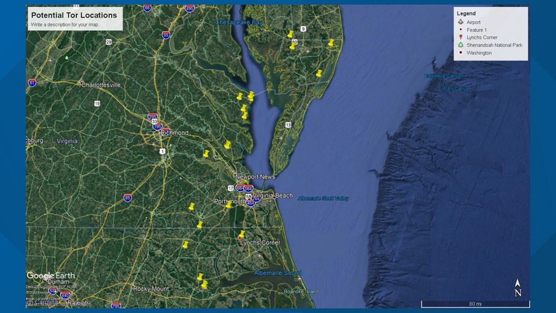
NORFOLK, Va. — The National Weather Service (NWS) said it knew that tornadoes hit at least a dozen locations in North Carolina, Virginia, and Maryland as Isaias traveled up the East Coast.
Jeff Orrock, Meteorologist in Charge, NOAA/NWS Wakefield, said surveyors would visit those locations in the coming days. Some of them were along the same track. Many of the spots were in northeastern North Carolina and Hampton Roads.
These are the 12 locations where NWS knew tornadoes hit as of early Tuesday afternoon:
North Carolina
- Windsor
- Como
- Lynchs Corner
- Menola
Virginia
- Courtland
- Suffolk
- James City County
- Fleeton/Buzzards Bay
- Kilmarnock
Maryland
- Mardela Springs
- Stockton to near SBY
- Catch Penny and Quantico
Orrock said there may be other locations, as well.

After making landfall as a Category 1 hurricane Monday night, Isaias still was a strong tropical storm at midday Tuesday.
The National Hurricane Center reports Hurricane Isaias made landfall in southern North Carolina around 11:10 p.m. Monday near Ocean Isle Beach, with maximum sustained winds of 85 mph, making it a Category 1 hurricane.
As of 11 a.m., Isaias is now situated near Baltimore, and is moving at about 35mph to the NNE. All of Hampton Roads remains under a Tropical Storm Warning, which means sustained winds of 40 mph are expected, and gusts to 70 mph will be possible.
There had been reports of a tornado touch down in Suffolk just before 4 a.m., and city officials reported storm damage from the Riverview neighborhood. Damages and impacts are being assessed in these and many other neighborhoods.
Many residents in Suffolk were without power, as strong winds buffeted the area.
Here's a look at some of the damages being reported across Hampton Roads:
The National Weather Service confirmed multiple tornado touchdowns form the overnight. One early in the morning was in the area of Conway and Severn in North Carolina. The tornado was reported moving northwest at 50 mph at around 2:35 a.m. More updates to come on confirmations after surveying from our local NWS branch in Wakefield including the suspected tornado touchdown in Bertie Co. Check back for survey results and tornado ratings in the next couple of days.
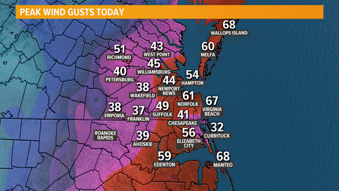
Strong winds continue to be of concern, but they will begin to rapidly decreasing as this evening rolls around. The graphic below features peak wind gusts observed from today alone which reiterates the point of extremely windy conditions associated with the movement and wind field of Isaias through Hampton Roads.

The Storm Surge alerts have been dropped in our area but we saw flooding for many locations near water. Elizabeth City and Virginia Beach were a couple of the regions that experienced high waters Tuesday morning.
DOWNLOAD: 13News Now App
DOWNLOAD: 13News Now Hurricane Guide
Isaias broke the record as the earliest ninth Atlantic named storm. The previous record-holder was Hurricane Irene, which formed on August 7, 2005.
RELATED: 13News Now Hurricane Guide 2020